


**New Military Dividing Line in Gaza**
The Israeli military is creating a new dividing line in the Gaza Strip, separating the far north of the territory from the rest. Satellite images studied by BBC Verify show troops controlling and clearing an area across the width of north Gaza.
**Huge Demolition Project**
Satellite images and videos show that hundreds of buildings have been demolished between the Mediterranean sea and the Israel border, mostly through controlled explosions. Israeli troops and vehicles have been stationed across the new divide.
**Purpose of the Partition**
Analysts say the images suggest Gaza is being split into zones to make it easier to control. An IDF spokesperson said they were “targeting terrorist operatives and infrastructure” in north Gaza.
**Concerns for Palestinian Civilians**
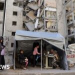
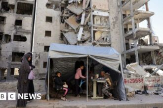
Dr H A Hellyer, a Middle East security expert from the Rusi think tank, said the satellite images suggested Israel was preparing to block Palestinian civilians from returning to the north Gaza governorate. More than 100,000 people have already been displaced from the far north of Gaza.
**UN Concerns**
The UN and aid charities have raised significant concerns about the situation in the north of Gaza. While thousands of people have been displaced, the UN says up to 60,000 people could remain in the area.
Read More @ www.bbc.com